

Abstract
The objective of this research is to analyze how the Land Use Plan (POT) and housing policy have shaped processes of socio-spatial reconfiguration and gentrification in the intermediate city of Armenia, Colombia. A mixed-methods approach is employed, combining quantitative analysis of land prices, building permits, housing types (social housing and non‑social housing), and verticalization for the period 2007–2022 with qualitative content analysis of POT regulations and urban planning documents, in order to assess their implementation and their effects on the urban and social structure of the city. The findings show that, during the validity of the POT, urban expansion was concentrated in a few specific communes where the arrival of non‑local population, the shift from social to non‑social housing, the predominance of new construction, and a strong concentration of apartments in middle‑ and upper‑income strata coincided with a differential increase in the price per square meter. These dynamics have generated conflictive mixtures of socioeconomic strata and displacement pressures on low‑income residents, configuring a pattern of policy‑induced gentrification in a city with limited regulatory capacity. The study concludes that territorial planning in Armenia—marked by weak governance and by an expired POT since 2022—has facilitated a fragmented growth model and an exclusionary revalorization of land, underscoring the need to revise land‑use instruments and housing policies in order to incorporate mechanisms for land regulation and the protection of vulnerable residents.
Keywords
Gentrificaction, City Planning, Land Use, Social Status, Cities
INTRODUCTION
Gentrification, a phenomenon increasingly studied in large cities and approached from different perspectives globally, has also become evident in intermediate Latin American cities, which require greater theoretical and practical attention. This process has been characterized by the arrival of groups with greater purchasing power in conventional neighborhoods, leading to real estate revaluation and the consequent displacement of the original inhabitants. This occurs within the different contexts of territorial planning and housing policies that shape the socio-spatial transformation dynamics of these cities.
Therefore, gentrification as a global urban strategy has nuanced the way urban studies are approached, overcoming neoliberal visions by extending across different case-study realities; it is understood as a strategy for dispossession and, consequently, for land rent capture by a minority. (1)
Various studies have analyzed the relationship between urban planning and gentrification; some evaluate the regulations and territorial planning instruments that affect private investment, describing the institutional designs that promote private capital investment in the city (2). Likewise, others have examined how these processes affect urban segregation and social exclusion in intermediate cities (3).
However, in the city of Armenia, Colombia, the relationship between the Land Management Plan (POT), housing policy, and gentrification has not been sufficiently analyzed despite the changes in land use, urban expansion, and recomposition of socioeconomic strata that evidence spatial reconfiguration processes. This article analyzes how the articulation between urban expansion, land policy, and land management instruments produces particular forms of gentrification in an intermediate city, where regulatory capacity is limited and social effects are acute.
The main contribution lies in identifying the mechanisms through which the POT and housing policy induce gentrification, revealing patterns of socio-spatial recomposition that cannot be explained solely by the dynamics of the real estate market but also by local planning and governance decisions. The analysis focuses on Armenia, but the findings allow for discussion of the implications for other intermediate Latin American cities. Thus, the study contributes to debates on gentrification in intermediate cities and on the role of the State in the creation of socio-spatial inequalities.
Theoretical Framework
The term gentrification describes the situation of populations in certain working-class neighborhoods that are subject to land revaluation and changes in the structural composition of their surroundings. (4) On this basis, recent debates on this phenomenon can be divided into two analytical perspectives.
The structural perspective examines gentrification as a consequence of the gap between the use value of land and its potential rental value, a gap exploited by private real estate capital. (5) The consumption perspective, in contrast, emphasizes the role of social classes and their residential preferences for central neighborhoods, through the concept of “revitalization” that drives neighborhood social change. (6) These approaches entail recognizing that gentrification cannot be explained solely by individual household decisions, but rather involves the articulation among the real estate market, cultural transformations, and state action.
In this sense, gentrification is understood in this study as a process of socio-spatial reconfiguration that combines economic valorization, social replacement, and transformation of the urban fabric.
Recently, various studies have begun to explore gentrification through the “rururban” concept, examining processes in intermediate cities where urban expansion advances over rural land, redefining the boundaries between countryside and city.
In these intermediate cities, low institutional capacity and dependence on national housing and competitiveness policies make the effects of territorial planning ambiguous. While it seeks to manage urban growth and attract investment, it can also intensify selective land valorization and socio-spatial segregation. This dual character has been documented in experiences of gentrification associated with the reconversion of productive land, the verticalization of consolidated areas, and the development of projects oriented toward tourism or emerging middle classes.
In the Colombian context, the Territorial Planning Plan (POT) is conceived as the main instrument to regulate land use, guide urban expansion, and define the conditions for the location of housing, facilities, and infrastructure. However, various studies have shown that POTs and other land management instruments can function as indirect mechanisms of gentrification by favoring the valorization of certain areas through regulatory changes, incentives for private investment, and flexibilization of land uses. Housing policy, particularly the distinction between Social Interest Housing (VIS) and Non-VIS, is intertwined with these processes by modulating which social groups access certain segments of the real estate market and in which parts of the city.
In intermediate cities such as Armenia, the articulation between POT, construction licenses, transition from VIS to Non-VIS, verticalization, and change in the vocation of rural land constitutes the central axis of socio-spatial reconfiguration. From the idea of “public policy-induced gentrification,” these state instruments produce new centralities, valorization corridors, and conflicting mixtures of strata, allowing the case of Armenia to be understood as part of a broader pattern of gentrification in Latin American intermediate cities.
METHODS
This research is exploratory in nature, which allows identifying and analyzing the causes and effects of gentrification in the city of Armenia. Likewise, this type of study is pertinent for conceptualizing phenomena relatively little addressed in the literature. (7) A mixed methodology is employed, in order to offer a more complete vision of the problem.
Regarding quantitative data, variables such as land price and construction permits for the period 2007–2022 are processed based on official records, which allows the identification of variations in land price levels and the inference of urban transformation patterns. Qualitative data, in turn, are obtained through documentary review and content analysis of the urban regulations contained in the Land Use Plan, with the aim of assessing their degree of compliance and interpreting how such regulations have influenced the spatial reconfiguration of the city and the spread of gentrification.
RESULTS
Territorial transformations and demographic pressure.
Between 2007 and 2022, the urban expansion of Armenia concentrated in a few communes where, in parallel, the arrival of outside population increased, configuring foci of demographic pressure and initial land revaluation. These dynamics constitute incipient signals of 'rururban' gentrification in an intermediate city.
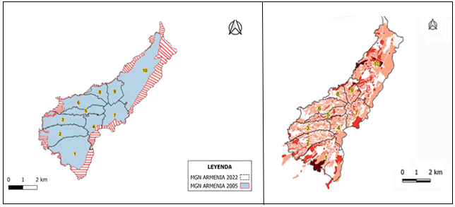
Source: Own elaboration with information supplied by (8)
Figure 1 shows that the communes Centenario (1), Rufino José Cuervo Sur (2), Alfonso López (3), and Quimbaya (10) record the greatest growth of urban land. In these areas, industrial, commercial, and residential projects are developed that significantly modify land use, changing from rural/coffee-growing vocation to urban, and increasing land value. The Centenario commune, in particular, experienced transformation driven by industrial facilities that, together with housing expansion, has modified land use and raised prices. (9) Similarly, the Rufino José Cuervo Sur commune expanded through a real estate boom, with residential complexes that energized lodging services.
Likewise, it shows that the distribution of non-local population coincides with the areas of greatest real estate dynamism. The communes with the greatest arrival of population from other municipalities also concentrate the intensity of urban transformation. This coincidence is not casual: demographic pressure generates housing demand that attracts real estate investment, while investment and renovation projects attract new residents with greater purchasing power. (10) The overlap of urban expansion, demographic pressure, and land revaluation in these communes suggests processes of rururban gentrification associated with the POT and the national housing policy, characteristic of intermediate Latin American cities where regulatory capacity is limited.
Construction licenses, VIS/No VIS, and verticalization.
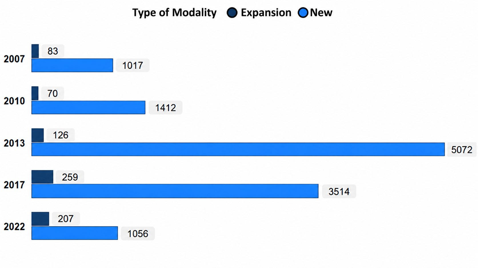
During the validity of the POT (2007–2022), new construction predominated over the expansion of existing housing, and there was a drastic shift from Social Interest Housing (VIS) to Non-VIS, accompanied by strong verticalization. These changes reflect how territorial planning instruments and housing policy function as mechanisms of gentrification induced by public policies, redirecting real estate investment toward higher-income strata.
Source: Own elaboration with information provided by (10)
Figure 2 shows that between 2007 and 2022, the new construction modality represented 92.6% of approved housing. The peak number of licenses was reached in 2013 with an increase of 259.2% compared to the previous year. In 2017, the second peak was recorded, where 93.1% corresponded to new housing. This dynamic reflects the importance of the POT in promoting urban expansion through large-scale construction.
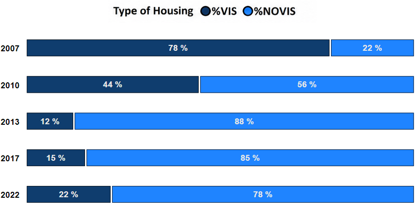
A fundamental change is observed in the transition from VIS to No VIS. In 2007, 78% of the housing units built were VIS and 22% No VIS. By 2017, this proportion had reversed: 70% No VIS and 30% VIS (Figure 3).
Source: Own elaboration with information provided by (10)
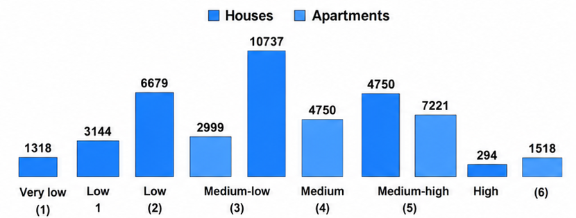
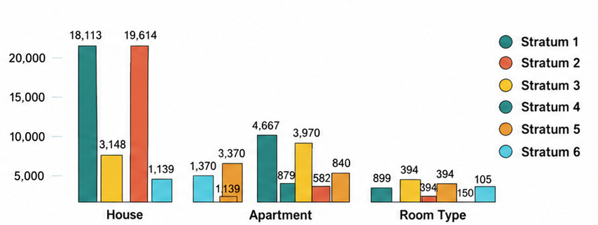
This change responds both to the reduction of available land and to a deliberate policy reorientation toward larger-scale projects, aimed at middle and high socioeconomic strata. Housing policy, by modulating the proportion of VIS/No VIS, exerts selective control over who gains access to urban land and at what price. Additionally, Figure 4 shows that between 2007 and 2022, apartments (vertical construction) were strongly concentrated in the middle-high and high socioeconomic strata, representing approximately 80% of the total.
Source: Own elaboration with information provided by (10)
In contrast, in lower strata, construction of houses predominated (60%). This bifurcation—apartments for upper strata, houses for lower strata—reflects a policy of spatial exploitation that favors the densification of value in specific areas (11). Verticalization thus becomes a territorial mechanism of gentrification: it allows for greater profit per square meter and attracts higher-income residents.
The combination of the shift from VIS to non-VIS, the increase in new construction, and the concentration of apartments in high strata constitutes what is interpreted as gentrification induced by public policies: the POT and housing policy actively redirect real estate investment toward higher-value projects, progressively excluding lower-income households from access to urban land.
Land prices and socio-spatial recomposition
The price per square meter increased in all strata during 2008–2016, but more intensely in the upper strata, configuring differential dynamics of valorization that pressure vulnerable populations and consolidate patterns of socio-spatial segregation. This increase, combined with the mix of strata in certain communes, generates conditions of gentrification: coexistence of social strata and potential displacement of original residents.
In the low-income stratum, the price per square meter increased from $264.472 pesos in 2008 to $586.576 in 2016, an increase of 121.79%. In stratum six (high income), the increase was more pronounced: from $1.356.805 to $3.161.851 pesos, equivalent to 133.04% (Figure 5). This differential increase indicates that land appreciation responds to real estate investment dynamics oriented toward high-income strata, which subsequently raise prices in lower-income sectors.
Source: Own elaboration using information provided by (10)
During this period, 939 construction licenses were approved, generating 7,801 housing units (6,930 apartments and 871 houses), with a strong concentration in vertical construction. The real estate boom, reflected in these licenses, correlates with the peaks of price increases. The territorial planning policies that promoted verticalization and the shift to No VIS acted as accelerators of selective land valorization.
Figure 6 shows the socioeconomic stratification in 2006 versus 2018. In the Centenario commune, an evident mixture of low, middle, and high strata is observed where low strata previously predominated. Similarly, the communes El Bosque (5) and Francisco de Paula Santander present similar phenomena of coexistence of different socioeconomic groups. According to gentrification theory, the presence of high-stratum housing in consolidated low-income neighborhoods attracts additional investments that transform local infrastructure, raise living costs, and increase pressure for the displacement of original families.

Source: Own elaboration using information provided by (8)
Differential price increases, the mix of strata in specific communes, and the concentration of verticalization in high strata configure the key pattern of gentrification in Armenia: the POT and housing policy produce new centralities and valorization corridors where the coexistence of strata generates pressure on the permanence of vulnerable populations. This process is characteristic of intermediate Latin American cities where planning instruments act as core agents of urban transformation and socio-spatial inequality.
DISCUSSION
The phenomenon of gentrification poses significant challenges for land-use planning policies, as it alters the urban structure and displaces the most vulnerable populations, favoring higher-income groups in their access to housing and urban services (12). In Armenia, the results show that the implementation of the Land Use Plan (POT) has been insufficient to mitigate these effects; on the contrary, it has favored the transformation of communes such as Centenario, Rufino José Cuervo Sur, and Alfonso López, where the coexistence of low- and high-income strata, the increase in land prices, and the rise of vertical housing projects have reshaped the socio-spatial structure of the city.
The normative complexity inherent in planning instruments hinders an effective response to real estate pressure and land use changes (13) (14). In Armenia, the lack of integration among public, private, and community interests reproduces these problems, limiting the institutional capacity to guide urban growth and contain exclusion processes. The findings confirm that the influence of pressure groups and the capture of strategic decisions for urban development have contributed to consolidating a city model that prioritizes investment, tourism, and the construction of projects aimed at middle and high strata (15) (16), identifying the State as a core agent in the configuration of urban space through policies that stimulate self-construction, verticalization, and differential land valorization (17).
The articulation between municipal policies and the promotion of areas attractive for investment, observable in the POT and in the development plans of Armenia, has directly influenced the housing modality and the type of approved developments. The transition from social interest housing (VIS) to non-VIS projects and the increase in the price per square meter reveal a pattern in which territorial planning instruments operate as socio-spatial selection devices rather than as guarantees of the right to the city (18) (19).
The analysis of the case of Armenia demonstrates that, although territorial planning aims at social cohesion and controlled growth, the lack of effective government–society coordination mechanisms and insufficient regulation have facilitated the consolidation of gentrifying dynamics and an exclusionary revaluation of the territory. (20)
This discussion converges with the findings of (21) and (22), who underscore the importance of equity and citizen participation in urban planning processes. The contribution of this study lies in showing how these processes manifest in an intermediate city with an expired POT and a marked VIS–No VIS transition, suggesting the need to review planning instruments and housing policies to incorporate land price regulation mechanisms, protection of vulnerable residents, and strengthening of participation in decision-making.
Conclusions
In Armenia, territorial planning is shaped by governance tensions that limit the capacity of the POT to guide equitable urban development, turning this instrument into a mechanism that, in fact, has contributed to gentrification. Weak coordination among actors, normative ambiguity regarding housing and socioeconomic stratification, and the priority given to projects aimed at middle and high strata have favored fragmented urban growth, selective land revaluation, and the conflictive mixing of social groups in new urbanization areas, with the risk of displacement for the vulnerable population.
The analysis of the 2008–2022 period shows that the POT drove urban expansion through road corridors, the transition from VIS to non-VIS, and strong verticalization, configuring a city model that associates competitiveness and investment with the concentration of high-value projects in certain communes. These decisions have directly influenced the increase in the price per square meter and the consolidation of centralities where access to housing is increasingly restricted to higher-income households. The absence, until 2025, of a new planning instrument deepens institutional uncertainty and may reinforce these dynamics of exclusionary revaluation.
Based on these findings, there is a need to review the territorial planning model and housing policy in intermediate cities such as Armenia, incorporating effective mechanisms for land regulation, price control, and protection of vulnerable residents, as well as citizen participation mechanisms that allow the democratization of decision-making on land use. It is suggested that future research delve deeper into the empirical measurement of residential displacement associated with these processes, evaluate the real impact of social housing programs, and analyze in detail the networks of actors involved in the configuration of the city, in order to advance toward a planning model that limits gentrification and guarantees the right to the city.
References
- 1 Benach N, Albet i Mas A. La gentrificación como una estrategia global. Papers. 2018 Jun;(60):17-23. Disponible en: https://ddd.uab.cat/record/194952
- 2 Molina-Saldarriaga CA, Salinas-Arreortua LA. Capital y desarrollo territorial. Diseños institucionales y gentrificación en el caso de la ciudad de Medellín, Colombia. Vniversitas [Internet]. 2018 Jan. 19 [cited 2025 Dec. 16];67(136):1-19. Available from: https://revistas.javeriana.edu.co/index.php/vnijuri/article/view/20931
- 3 Navarrete Escobedo D. La gentrificación trasnacional en América Latina: el caso de San Miguel de Allende. Iztapalapa Rev Cienc Soc Humanid. 2022;2(93):103-128. doi: 10.28928/ri/932022/atc4/navarreteescobedod
- 4 Glass R. London: Aspects of Change. London: MacGibbon & Kee; 1964
- 5 Smith N. Toward a theory of gentrification: A back to the city movement by capital, not people. J Am Plann Assoc. 1979;45(4):538 48
- 6 Ley D. Gentrification and the politics of the new middle class. Environ Plan D Soc Space. 1994;12(1):53 74. doi:10.1068/d120053..
- 7 Hernández-Sampieri R, Mendoza C. Metodología de la investigación: las rutas cuantitativa, cualitativa y mixta. Ciudad de México: McGraw-Hill Education; 2018. 714 p. ISBN: 978-1-4562-6096-5.
- 8 Departamento Administrativo Nacional de Estadística (DANE). Censo Nacional de Población y Vivienda 2018. Bogotá: DANE; 2018. Disponible en: https://www.dane.gov.co/index.php/estadisticas-por-tema/mercado-laboral/empleo-y-desempleo/geih-historicos
- 9 Giménez García R, García Marín R. Expansión urbana y transformación de coberturas y usos de suelo en la Aglomeración Urbana de Murcia. Bol Asoc Geogr Esp. 2023;(96). doi:10.21138/bage.3269..
- 10 Rodríguez Gonzalo-Martín G. Desplazamientos y gentrificación, ¿una relación necesaria? Estudio cuantitativo en la ciudad de Córdoba, Argentina (1991–2010). EURE (Santiago). 2021;47(142):73–96. doi:10.7764/eure.47.142.04..
- 11 Departamento Administrativo Nacional de Estadística (DANE). Estadísticas de licencias de construcción. Bogotá: DANE; 2022. Disponible en: https://www.dane.gov.co/index.php/estadisticas-por-tema/construccion/licencias-de-construccion
- 12 Gonzalez-Argote J, Maldonado EJ. Displacement as a social problem and its relationship to gentrification. Gentrification. 2024;2:67. doi:10.62486/gen202467..
- 13 Bailey N, Minton J. The suburbanisation of poverty in British cities, 2004–16: extent, processes and nature. Urban Geogr. 2018;39(6):892–915. doi:10.1080/02723638.2017.1405689..
- 14 González OL. El Sistema de Planeamiento de Canarias: innovaciones normativas y consecuencias territoriales. Cuad Geogr. 2020;59(3):122–141. doi:10.30827/cuadgeo.v59i3.11184..
- 15 Nel·lo O. Els conflictes territorials a Catalunya. Orígens, dinàmica i alternatives. En: Nel·lo O, editor. Aquí, no! Els conflictes territorials a Catalunya. Barcelona: Empúries; 2003. p. 11–67.
- 16 Healey P. Urban complexity and spatial strategies: towards a relational planning for our times. London; New York: Routledge; 2007.
- 17 Benabent M. Teorías de la planificación territorial: métodos de decisión. Ciudad Territ Estud Territ. 2016;48(189):353–368. Disponible en: https://recyt.fecyt.es/index.php/CyTET/article/view/76487
- 18 Finck N, Lobato S, Moreno Russo MF, Martinez MA. El rol de la política urbana de suelo y vivienda en el proceso de expansión en dos ciudades fueguinas (Argentina) durante el período 2005–2015. Cuad Urbano. 2022;33(33):161. doi:10.30972/crn.33336234..
- 19 Steel G, Klaufus C. Displacement by/for development in two Andean cities [Internet]. 2010 [citado 16 de agosto consulta]. Disponible en: https://www.researchgate.net/publication/315542207_Displacement_byfor_development_in_two_Andean_cities
- 20 Lima C. Una mirada crítica a la zona portuaria de Río de Janeiro. Bitácora Urbano Territorial. 2010;17(2):23–54. Disponible en: https://revistas.unal.edu.co/index.php/bitacora/article/view/18892
- 21 Pérez León M. The impact of gentrification policies on urban development. Gentrification. 2023;1:4. doi:10.62486/gen20234..
- 22 Molina-Saldarriaga, C. A., & Salinas-Arreortua, L. A. (2018). Capital y Desarrollo Territorial. Diseños institucionales y Gentrificación en el caso de Medellín, Colombia. Vniversitas, 67(136), 1–19. https://doi.org/10.11144/Javeriana.vj136.cdtd
- 23 Orellana-Alvear B, Calle-Jiménez T, Yulán L. Herramientas de apoyo al ordenamiento territorial: propuesta de indicadores de gentrificación aplicado a ciudades intermedias del Ecuador. Estud Perspect Rev Cient Acad. 2024;4(1):416–446. doi:10.61384/r.c.a..v4i1.106..
Declarations
Funding
None
Conflict of interest
The authors declare no conflict of interest.
Authorship contributions
Conceptualization: Juan Andrés Franco and Fabian Steven Henao Palacios.
Data curation: Juan Andrés Franco and Fabian Steven Henao Palacios.
Formal analysis: Juan Andrés Franco and Fabian Steven Henao Palacios.
Research: Juan Andrés Franco and Fabian Steven Henao Palacios.
Writing – Juan Andrés Franco and Fabian Steven Henao Palacios.
Writing – Juan Andrés Franco and Fabian Steven Henao Palacios.