

Abstract
Low-traffic neighbourhoods restrict through motor traffic on residential streets to support walking and cycling, but their effects on traffic, active travel, air quality and equity remain contested. Eleven studies were included. Motor traffic fell inside schemes, by 56% and 61% in two natural experiments, with limited evidence of displacement to boundary roads. Active travel increased, by 65 to 114 additional minutes per week in the most intensively treated areas. One study reported lower nitrogen dioxide on low-traffic neighbourhood roads, and spatial analyses found schemes more likely in deprived and car-free areas of London. Low-traffic neighbourhoods reduce motor traffic and increase active travel in most settings, with thinner evidence on air quality and broadly favourable distributional patterns, although the evidence base is concentrated in the United Kingdom and relies on non-randomised designs.
Keywords
low traffic neighbourhoods, active travel, traffic volume, air quality, health equity
INTRODUCTION
Motor traffic on residential streets produces noise, air pollution, community severance and road danger, and it suppresses the walking and cycling that public health policy seeks to promote.( 1) These harms fall unevenly, because deprived and car-free households are often exposed to the highest volumes of through traffic while having the least access to private vehicles.( 2)
In response, several cities have begun to reallocate street space away from motor vehicles, and one of the most visible instruments for doing so is the low-traffic neighbourhood (LTN), an area-based scheme in which modal filters such as bollards, planters and camera gates remove through motor traffic from residential streets while keeping access for residents and for people on foot or on a bicycle.( 3)
The policy context is the search for a calmer mobility paradigm that reduces car dependence and its externalities.( 4) In the United Kingdom, local authorities used emergency active-travel funding during the COVID-19 pandemic to introduce schemes rapidly, and by October 2020 around 4% of the population of Greater London lived inside a scheme implemented between March and September of that year.( 5)
The roll-out was politically contentious, with some schemes removed after local backlash and with public debate centred on whether traffic was displaced onto boundary roads and on whether the interventions favoured affluent areas.( 6,7) These controversies make the evaluation evidence unusually important, because decisions to retain or remove schemes have often been taken under public pressure rather than on the basis of measured effects.( 8)
Each of the four outcomes reviewed here carries a distinct policy weight. Motor traffic is the primary outcome because the stated purpose of modal filters is to remove through traffic, and because the risk of displacing it to boundary roads is the most frequent criticism of the schemes.( 9)
Active travel is the health-relevant pathway, since additional walking and cycling translate into physical activity and measurable health economic benefits.( 10)
Air quality matters because traffic restriction can reduce nitrogen dioxide and particulate matter in principle, but it can also concentrate emissions where traffic reroutes, so the net effect on exposure is an empirical question rather than a foregone conclusion.( 11)
Equity matters because interventions that change who can use a street may distribute benefits and burdens unevenly across income, ethnicity and age groups, and this concern has been central to the public debate.( 5)
LTNs belong to a longer tradition of filtered permeability and traffic evaporation, the observation that reducing road capacity for motor vehicles does not simply move all trips elsewhere but can lead some trips to disappear or to shift to walking, cycling and public transport.( 12)
Earlier evidence on traffic calming reviewed these mechanisms mainly for point interventions such as speed humps, and a recent meta-analysis of traffic calming and crash reduction did not resolve the question of what happens to traffic volumes and mode share when an entire neighbourhood is filtered.( 13)
Reviews of active transportation interventions report benefits for walking and cycling on average, but they have not isolated the contribution of area-wide modal filtering from other infrastructure such as cycle tracks.( 14)
The emerging evidence falls into two families. Survey-based longitudinal studies in Outer London have compared residents of low-traffic neighbourhood areas with control areas and reported more walking and cycling alongside lower car ownership and use.( 15,16)
Traffic-count and vehicle-record studies have measured motor traffic directly, either on streets inside schemes or through the mileage of residents' vehicles, and have generally reported reductions rather than displacement.( 17,18)
A third, smaller body of work has examined the distribution of schemes and the lived experience of residents, where the findings are more mixed.( 5,19)
This evidence has grown quickly since 2020 but remains scattered across transport, health and urban studies journals, and no synthesis to date has assembled the four outcomes that dominate the public debate: motor traffic inside and around the schemes, active travel, air quality and equity. Individual evaluations have reported traffic reductions, increases in walking and cycling and broadly equitable placement in London, while other studies have questioned the air-quality benefits and documented perceptions of unfairness on unfiltered streets.( 11,19)
A dedicated synthesis is needed to establish the direction and strength of the evidence and to identify where it remains thin.
The objective of this review was to synthesize the evidence on the effects of low-traffic neighbourhoods on motor traffic inside and around the schemes, on active travel, on air quality and on equity. Motor traffic was treated as the primary outcome, and active travel, air quality and equity as secondary outcomes, with the synthesis and the reporting structured in that order.
METHODS
This systematic review followed the PRISMA 2020 statement.( 20) Studies were eligible if they reported an empirical evaluation of a low-traffic neighbourhood or a comparable area-based scheme of modal filters that restricts through motor traffic on residential streets, and if they measured at least one of four outcomes: motor traffic volumes or speeds inside or around the scheme, active travel such as walking or cycling, air quality, or equity in outcomes or in the distribution of schemes. In population, intervention, comparison, outcome and study-design terms, the review covered residents and streets of residential neighbourhoods, area-based modal filters, comparison areas without filters or before-after contrasts, the four outcomes listed above, and observational designs.
Observational designs were considered, including before-after studies, cross-sectional analyses, quasi-experimental studies with comparison groups, and qualitative or mixed-methods evaluations. Studies published before 2013 or after 2025 were excluded, as were studies of single point interventions such as isolated speed humps and studies that reported only attitudes or political outcomes without measuring any of the four outcomes. Only publications with a retrievable open-access full text or a deposited author manuscript were assessed at the full-text stage.
Scopus was searched first, followed by OpenAlex, Crossref and Semantic Scholar, using field-based queries that combined variants of the term low-traffic neighbourhood with modal filter and with outcome terms. The principal Scopus query was TITLE-ABS-KEY("low traffic neighbourhood" OR "low traffic neighborhood" OR "low-traffic neighbourhood" OR "low-traffic neighborhood") combined with a publication year filter from 2013 to 2025, and this query was repeated with the plural variants, with outcome terms, and with the term modal filter combined with traffic, cycling, walking or active travel. The same core concepts were translated for OpenAlex, Crossref and Semantic Scholar.
For each included study, one author extracted the country, design, population or sample, exposure, outcomes and the main result with its estimate and confidence interval, together with the section or page where each datum was located. A second check of the extracted values against the source documents was performed during drafting. The extraction was recorded in a structured table and is summarized in this report.
The data items extracted for each study were the study design, country and city, the intervention and any comparison condition, the population or sample size, the outcome measures, the main effect estimate with its confidence interval, and the information relevant to each risk-of-bias domain. Where a study reported several waves or sites, the estimates closest to the primary outcome were extracted first, and the secondary outcomes were then extracted in the order active travel, air quality and equity. Estimates were taken from the adjusted analyses when the authors presented them, and the form of the estimate, such as a rate ratio or a difference in means, was preserved rather than standardised.
A narrative synthesis was structured by outcome, with motor traffic defined as the primary outcome and active travel, air quality and equity as secondary outcomes, in line with the hierarchy used in the review question.
RESULTS
Study selection
Database searches identified 384 records, comprising 154 from Scopus, 130 from OpenAlex, 50 from Crossref and 50 from Semantic Scholar, of which 207 were duplicates, leaving 177 records screened by title and abstract. Of these, 160 were excluded and 17 reports were sought for retrieval. The main reasons for exclusion at title and abstract were that the record did not evaluate a low-traffic neighbourhood or a comparable modal-filter scheme, that it concerned a different intervention such as a single speed hump or a cycle track, that it reported only attitudes or political outcomes without measuring the four outcomes, or that it was a duplicate report of an already identified study (Figure 1).
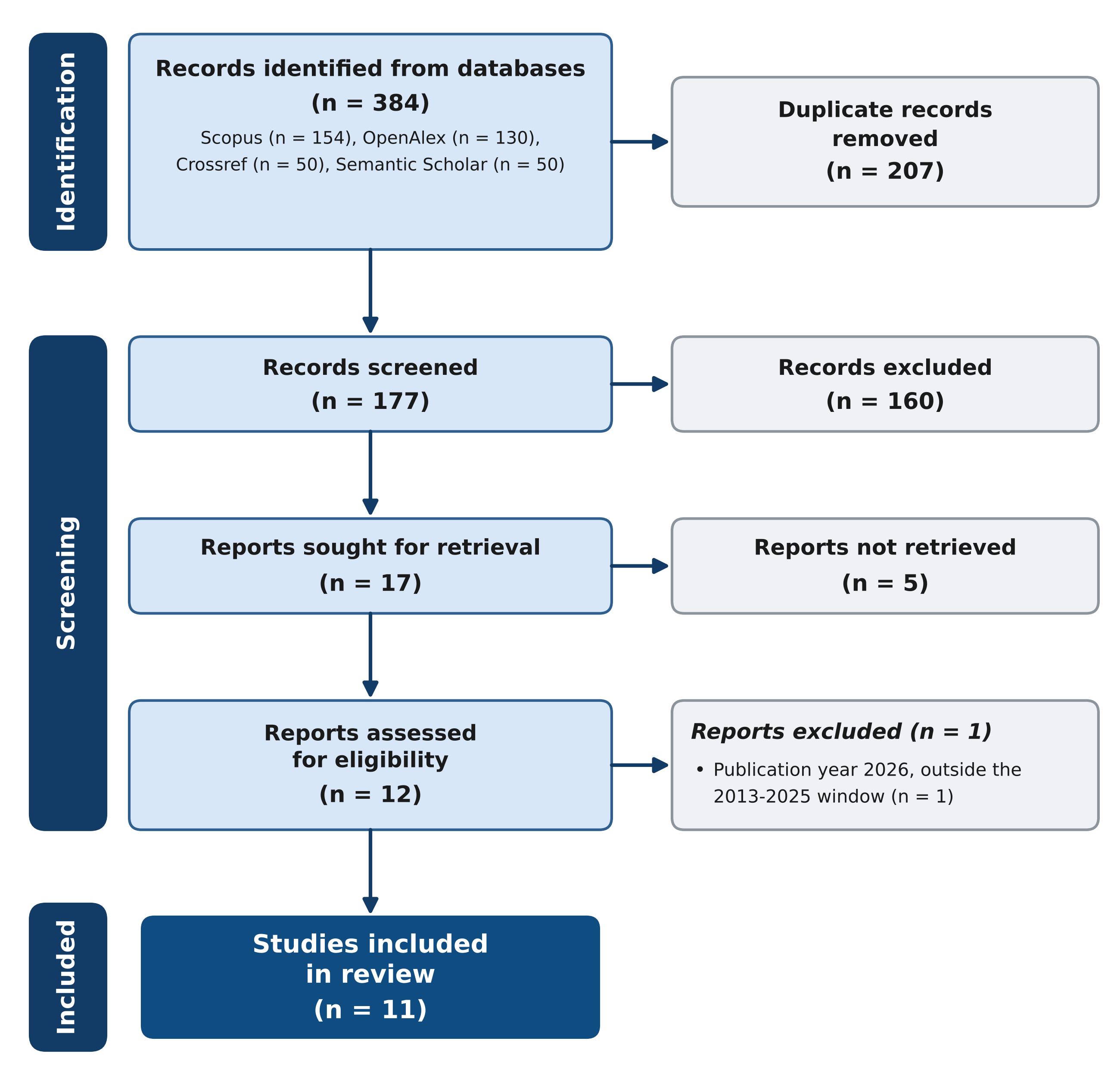
Figure 1. PRISMA 2020 flow diagram of study selection.
Characteristics of included studies
The 11 included studies were published between 2020 and 2025. Ten were conducted in the United Kingdom, nine of them in London, and one in Frankfurt, Germany. The designs comprised five longitudinal or repeated cross-sectional surveys, two natural experiments with matched controls, one difference-in-differences analysis of vehicle registration records, one difference-in-differences analysis of traffic counts, one spatial equity analysis and one mixed-methods street evaluation.
Outcome measurement varied accordingly, from automatic traffic counters and video monitors, through vehicle odometer records and passive nitrogen dioxide monitors, to self-reported travel diaries and coded free-text consultation responses. The samples ranged from 49 to 66 participants in the low-traffic neighbourhood arm of the earliest survey to 2881 small areas in the vehicle-ownership analysis.
The interventions were homogeneous in mechanism, all using modal filters to restrict through motor traffic, but differed in scale, from filters across a single commercial street in Frankfurt to 412 filters across 84 areas in London. Nine of the London studies evaluated schemes introduced under the 2020 emergency active-travel programme or the earlier mini-Holland programme, and the remaining two examined schemes in Birmingham and in Frankfurt. The characteristics of the included studies are summarized in (Table 1).
Study | Country | Design | Population or sample | Outcomes | Main finding |
|---|---|---|---|---|---|
Verlinghieri et al. 2025 | UK (London) | Mixed methods: sensors and interviews | One LTN and its boundary roads | Boundary road congestion | Most boundary roads changed little; two roads increased |
Whelan et al. 2024 | UK (Birmingham) | Mixed methods: NO2 monitoring and survey | 210 residents; 19 monitoring sites | NO2; community perceptions | Lower NO2 on LTN roads; polarised community |
Pritchett et al. 2024 | UK (Birmingham) | Qualitative thematic analysis | 3,751 pre and 791 post responses | Lived experiences | Benefits and perceived harms; discrimination on unfiltered streets |
Aldred et al. 2024 | UK (Outer London) | Longitudinal cohort, 6 years | 3,435 at baseline; 1,354 at wave 5 | Active travel; car use; health economics | 65-114 more active minutes per week in LTN areas |
Xiao et al. 2023 | UK (Southwark) | Natural experiment with DiD | 3 LTNs and matched controls | Traffic; speeds; walking; cycling | Traffic fell 56% and 61% in two areas; boundary traffic rose 17% in one |
Goodman et al. 2023 | UK (Lambeth) | DiD of vehicle records | 4 LTNs; 8,575 and 10,281 vehicles | Daily kilometres driven | 1.3 fewer km/day (6.4%) in LTN areas |
Aldred et al. 2021 | UK (London) | Spatial cross-sectional | 84 LTN areas; 412 modal filters | Distributional equity | Deprived areas 2.7 times more likely inside an LTN |
Aldred and Goodman 2021 | UK (Outer London) | Longitudinal survey | 2,210 participants | Walking; cycling; car use | 58-69 more active minutes per week; car use fell |
Goodman et al. 2020 | UK (Outer London) | DiD of registration data | 2,881 small areas | Car and van ownership | 6% fewer cars and vans after two years |
Aldred and Goodman 2020 | UK (Outer London) | Longitudinal survey | 962 control; 49-66 in LTN areas | Car use; walking; cycling | Car ownership ratio 0.80; cycling ratios 1.46-1.68 |
Knese 2025 | Germany (Frankfurt) | Mixed methods | 925 and 1,944 surveys | Mode use; traffic; safety | Traffic fell from 7,683 to 4,444 vehicles per day |
Note: LTN = low-traffic neighbourhood; DiD = difference in differences; UK = United Kingdom.
Risk of bias
All studies were non-randomised, and most were graded at moderate risk of bias. The main sources of risk were confounding by the COVID-19 pandemic and by concurrent infrastructure investment, small samples in the low-traffic neighbourhood groups, and reliance on self-reported travel behaviour in the survey-based studies. Three studies were graded at serious risk of bias, one because it evaluated a single case without a comparison group, one because its consultation sample was self-selected, and one because it lacked primary pre-intervention data.
No study was graded at low risk of bias. In the survey-based studies, the measurement of outcomes relied on self-reported past-week travel, which was graded as serious for the outcome-measurement domain in three studies, because recall error could attenuate or inflate the reported change. The traffic-count and vehicle-record studies were graded as moderate on outcome measurement because their instruments were objective, but the allocation of areas to intervention or control could not be blinded. The judgements are shown in (Table 2).
Study | Confounding | Participant selection | Intervention classification | Outcome measurement | Overall |
|---|---|---|---|---|---|
Verlinghieri et al. 2025 | S | S | M | M | S |
Whelan et al. 2024 | S | M | M | M | M |
Pritchett et al. 2024 | S | S | M | M | S |
Aldred et al. 2024 | M | M | M | S | M |
Xiao et al. 2023 | M | M | M | M | M |
Goodman et al. 2023 | M | M | M | M | M |
Aldred et al. 2021 | M | M | M | M | M |
Aldred and Goodman 2021 | M | M | M | S | M |
Goodman et al. 2020 | M | M | M | M | M |
Aldred and Goodman 2020 | M | M | M | S | M |
Knese 2025 | S | M | M | S | S |
Note: M = moderate risk; S = serious risk. No study was graded at low risk.
Primary outcome: motor traffic
Motor traffic inside the schemes decreased in the studies that measured it directly. In a natural experiment in Southwark with matched control neighbourhoods, daily traffic counts on project streets fell by 860 vehicles (95% CI 409 to 1312), a 56% decrease (incidence rate ratio 0.44, 95% CI 0.28 to 0.68), in Brunswick Park and by 937 vehicles (95% CI 328 to 1546), a 61% decrease (incidence rate ratio 0.39, 95% CI 0.26 to 0.71), in North Peckham, while counts in East Faraday did not differ from the control.( 17)
Traffic speeds also decreased in all three neighbourhoods, with reductions in the 85th percentile of 4.74 to 7.13 kilometres per hour, and the proportion of vehicles travelling over the posted speed limit fell in all three project areas.( 17)
The reductions were similar on weekdays and weekends, with weekdays showing the larger decreases.(17) Among residents of four Lambeth schemes, a difference-in-differences analysis of vehicle mileage records estimated a reduction of 1.3 km driven per day (95% CI 0.3 to 2.4), a relative decrease of 6.4%, in low-traffic neighbourhood areas compared with control areas, based on 8575 vehicles before and 10281 after; the mean past-year driving fell by 0.7 km per day inside the schemes and rose by 0.6 km per day in control areas elsewhere in the borough.(18)
Consistent with these findings, car or van ownership fell by 6%, equivalent to 23 fewer vehicles per 1000 adults, after two years in low-traffic neighbourhood areas of Outer London, against 2% in areas receiving other active-travel infrastructure, across 2881 small areas.(22) The ownership reductions were larger after adjustment for the changing age profile of the intervention areas, reaching 7% after two years, and they were observed for cars and vans but not for motorcycles, which argues against a purely compositional explanation.(22)
Evidence on boundary roads was mixed. The Southwark study recorded an increase of 1548 vehicles on weekdays (95% CI 571 to 2526), a 17% increase, on the boundary streets of Brunswick Park, but the confidence intervals for the other two neighbourhoods were wide and crossed the null, and no change in driving was detected on the boundary streets of North Peckham or East Faraday.( 17)
A sensor study of a single London scheme found that the percentage of congested journeys changed little on most boundary roads, between -1.9 and +1.0 percentage points, although two roads showed larger increases, from 12.9% to 19.1% on one road and from 0.2% to 9.6% on another.( 9)
In Frankfurt, average daily motor traffic on the redesigned Oeder Weg fell from 7683 vehicles in 2019 to 4444 in 2023, a 42% reduction, and bicycle counts rose from 3763 to 4706 over the same period.( 23)
Across the three objective traffic measures of street counts, resident mileage and vehicle ownership, the direction of change was the same, and the magnitude was largest in the count-based studies that measured traffic on the filtered streets themselves. The primary outcome estimates are collated in (Table 3).
Study | Site | Absolute change (95% CI) | Relative change |
|---|---|---|---|
Xiao et al. 2023 | Brunswick Park, project streets | -860 vehicles/day (-1312 to -409) | -56% (IRR 0.44) |
Xiao et al. 2023 | North Peckham, project streets | -937 vehicles/day (-1546 to -328) | -61% (IRR 0.39) |
Xiao et al. 2023 | East Faraday, project streets | 291 vehicles/day (-2101 to 2683) | No significant change |
Goodman et al. 2023 | Lambeth, resident driving | -1.3 km/day (-2.4 to -0.3) | -6.4% |
Goodman et al. 2020 | Outer London, cars and vans | -23 per 1000 adults after 2 years | -6% |
Knese 2025 | Frankfurt, Oeder Weg | -3239 vehicles/day (7683 to 4444) | -42% |
Xiao et al. 2023 | Brunswick Park, boundary weekdays | +1548 vehicles/day (+571 to +2526) | +17% |
Verlinghieri et al. 2025 | London case, most boundary roads | -1.9 to +1.0 percentage points | Largely unchanged |
Note: CI = confidence interval; IRR = incidence rate ratio. Negative values indicate a reduction in traffic.
Secondary outcomes: active travel, air quality and equity
Active travel increased in the survey-based evaluations. In the five-year People and Places cohort, residents of low-traffic neighbourhood areas gained between 65 and 114 additional minutes of active travel per week across waves, with the strongest evidence for increased cycling participation, while car ownership and use declined in the same group; the cohort comprised 3435 participants at baseline and 1354 at the fifth wave.( 10)
A comparison of emergency and longer-standing schemes found increases of 58 and 69 minutes of active travel per week respectively, although the samples were small, with 65 and 61 participants in the two arms.( 16)
The earlier three-wave analysis reported rate ratios for any past-week cycling of 1.46 in wave 1 and 1.68 in wave 3 in low-traffic neighbourhood areas, and rate ratios for any past-week walking of 1.14 and 1.11, among 49 to 66 participants in the low-traffic neighbourhood group.( 15)
By contrast, the Southwark natural experiment found no general change in observed walking or cycling, except for an increase of 202 children walking per day, a 430% increase, in one neighbourhood, and a decrease of 31 adult cyclists per day, a 68% decrease with a confidence interval that crossed the null, in another.( 17)
The five-year cohort reported the largest absolute gains for walking, with the strongest evidence of new participation for cycling, which the authors attributed to the low baseline prevalence of cycling in the sample.( 10)
The perception data reinforced the behavioural findings. In the pandemic wave of the People and Places survey, residents of emergency schemes rated the cycling environment more favourably, with rate ratios of 1.90 for perceived traffic safety when cycling and 1.70 for the presence of cycling lanes or paths, and there was no evidence of change for most non-cycling aspects of the local environment.( 16)
In Frankfurt, 69% and 55% of respondents in two surveys reported more cycling and walking after the redesign of Oeder Weg, and half reported using the car less, while 4% of drivers were observed to ignore the modal filter.( 23)
Air quality was examined in one included study. In Kings Heath, Birmingham, nitrogen dioxide on low-traffic neighbourhood roads averaged 23.65 micrograms per cubic metre in December 2020 against 25.01 on other roads, and 9.52 against 13.13 by July 2023, although concentrations still exceeded the 2021 World Health Organization guideline of 10 micrograms per cubic metre.( 24)
Seasonal analyses showed summer nitrogen dioxide about 25% to 30% lower than winter in each year from 2021 to 2023, and mean concentrations on one main road declined from 40 to 27.65 micrograms per cubic metre between 2016 and 2022, an average decrease of 5.2% per year.( 24)
Equity findings were broadly favourable at the city scale. Across London, people in the most deprived quarter of areas were 2.7 times more likely to live inside a new low-traffic neighbourhood than those in the least deprived quarter, car-free households and Black residents were overrepresented, and Asian residents were underrepresented, while disability status showed little difference, with 3.9% of residents with activity limitations living inside a scheme.( 5)
At district level the picture varied, with more deprived and minority ethnic residents more likely to live in a scheme in some districts and less likely in others, and with residents inside schemes demographically similar to their neighbours on adjacent boundary roads, which suggests that the areas receiving filters were not more advantaged than the streets immediately around them.( 5)
Qualitative work in Birmingham recorded both perceived benefits, such as less traffic and more active travel, and perceived harms, including displaced traffic and a sense of discrimination among residents of streets without filters, across 3751 pre-scheme and 791 post-scheme consultation responses.( 19)
Residents valued the reduction in traffic and the safer conditions for walking and cycling, but residents of streets without filters described increased traffic, inconvenience and a sense that the schemes redistributed burdens rather than removing them, and disabled car users reported particular difficulties.( 19)
DISCUSSION
The main finding of this review is that low-traffic neighbourhoods reduced motor traffic inside the schemes in the studies that measured it directly, with reductions of 56% and 61% in the two Southwark schemes and smaller but consistent declines in car use and ownership among residents. The evidence on active travel pointed in the same direction, with the largest gains in low-traffic neighbourhood areas, while the evidence on air quality was thin and the evidence on equity was broadly reassuring at the city scale but more mixed at the street scale.
The hierarchy of the review question should be kept in view when weighing these results. The primary outcome, motor traffic, rests on objective measurements in the two natural experiments and on vehicle records, and its direction is consistent across designs. The secondary outcomes rely more heavily on self-report and on single studies, particularly air quality, which is supported by only one included study, and the equity conclusions rest on one spatial analysis at the city scale plus qualitative work at the street scale. These secondary findings are therefore presented with less confidence, and they should be treated as indicative rather than definitive until more studies accumulate.
The traffic reductions are consistent with the concept of traffic evaporation described by Cairns and colleagues, who reviewed dozens of road-space reallocation schemes and found that road-space reallocation often removes more trips than it displaces, with average reductions in traffic on treated streets and no equivalent growth on surrounding roads.( 12)
They also align with evaluations of tactical urbanism in Barcelona, where removing through traffic reduced rather than relocated motor traffic,( 25) with a review of road closures that concluded displacement was generally smaller than feared,( 26) and with floating-car data from Bologna that showed no systematic worsening of surrounding roads after street reallocation, once seasonal and background changes were accounted for.( 27)
The boundary-road findings add a caveat, because the Southwark study detected a 17% increase on one set of boundary streets and the London sensor study showed localised increases on two roads.( 9,17)
This mixed pattern suggests that displacement is real in some locations but is not the dominant response across schemes, a conclusion that also fits the Frankfurt observation that the whole neighbourhood lost traffic even though some nearby roads gained it.( 23)
For active travel, the positive survey findings are consistent with a review of active transportation interventions that reported benefits for walking and cycling,( 14) with a natural experimental evaluation of School Streets that found gains in children's active travel and road safety perceptions,( 28) and with evidence that the determinants of cycling include the kind of low-stress street environment that modal filters create.( 29)
The gains also grew over time in the more established schemes, which suggests that benefits may accumulate as residents adjust their habits and as complementary infrastructure is added.( 10) The null walking and cycling results in Southwark are the main discrepancy, and they probably reflect a setting where active travel was already high, around 40% of trips, so the scope for further mode shift was limited.( 17)
The difference also echoes a systematic review of traffic calming that found inconclusive effects on walking and cycling,( 13) and it cautions against assuming that traffic reductions automatically convert into active travel.
The importance of a low-stress street environment to cycling is supported by a review of the environmental determinants of cycling, which found that traffic safety and route continuity shape the decision to cycle.( 29) T
he School Street evidence extends the same logic to children, where removing traffic at the school gate increased active travel and perceived safety.( 28) These parallels suggest that the mechanism of low-traffic neighbourhoods generalises beyond the London context, although the German study remains the only direct non-UK evaluation.( 23)
The health-economic framing strengthens the case for the active-travel pathway. In the five-year People and Places cohort, the mini-Holland programme was estimated to generate a 20-year health economic benefit of 1056 million pounds from a programme cost of about 100 million pounds, with 821 million pounds attributable to reduced mortality from additional physical activity.( 10)
The low-traffic neighbourhood component was estimated at 4800 pounds per person against a per-person cost of 28 to 35 pounds, which suggests that even modest increases in walking and cycling can justify the investment on health grounds alone.( 10) These figures should be read with the caveat that they are modelled rather than observed, but they indicate that the active-travel gains reported in the surveys are large enough to matter for population health.
Air quality was the least studied outcome, with only one included study measuring nitrogen dioxide, and the principal quantitative evaluation of nitrogen dioxide and traffic could not be retrieved in full text because it was not available through open access.( 11,24)
The Birmingham monitoring data are consistent with modelling of zone-30 policies, which found modest reductions in road emissions,(30) and with the broader argument that urban redesign can improve respiratory environments, but the magnitude of any air-quality benefit from low-traffic neighbourhoods remains uncertain.(31) The community study in Birmingham found that residents perceived air-quality and health improvements unevenly across the scheme, which suggests that measured and perceived environmental benefits may diverge.(24)
Until a retrievable quantitative evaluation fills this gap, air-quality claims about low-traffic neighbourhoods should be made cautiously and should distinguish measured concentrations from modelled expectations. The noise evaluation from Oxford provides complementary evidence that environmental exposures can improve inside schemes, although noise was outside the scope of this review's outcomes.( 32)
The equity results challenge the claim that low-traffic neighbourhoods were placed mainly in affluent areas. The London spatial analysis found the most deprived quarter 2.7 times more likely to live inside a scheme, a pattern that contrasts with concerns about distributional fairness in street redesign more generally.( 2,5)
The same concern is visible in analyses of the 15-minute city in Oslo, where proximity-based measures can mask unequal access to destinations and equity therefore depends on how accessibility is measured, and in work on cycling among older people, where inclusion is not automatic and depends on the comfort and safety of the routes provided.( 33,34)
The qualitative Birmingham findings nevertheless show that perceived unfairness can persist between filtered and unfiltered streets within the same neighbourhood, which is a reminder that equity operates at several scales.(19) These results are consistent with arguments that active mobility policy needs explicit equity monitoring rather than an assumption that infrastructure benefits everyone equally,(35) and with resident surveys in Oxford that found support for schemes but divergent views according to household circumstances.(36)
Consistent with a dose-response pattern, the magnitude of active-travel change was larger in the more intensively treated low-traffic neighbourhood areas than in areas receiving only other active-travel infrastructure.( 10,15)
The vehicle-ownership analysis showed the same gradient, with effects two to three times larger in low-traffic neighbourhood areas than in other infrastructure areas after the same duration.( 22)
After excluding the single German study, the direction of the traffic findings was unchanged, and no included study reported a sustained increase in traffic inside a scheme, which supports the robustness of the primary outcome.
Heterogeneity across the studies reflects differences in context, measurement and timing. The London schemes were introduced against a background of falling background traffic and pandemic-related travel disruption, whereas the Frankfurt evaluation captured the post-pandemic reallocation of a single commercial street.( 23)
Survey-based studies measured self-reported past-week travel, while the Southwark and Lambeth studies used counters and vehicle records, and these measurement choices plausibly explain part of the divergence in active-travel findings.( 17,18)
The mechanism common to the consistent findings is that removing through traffic changes the relative cost of driving and makes walking and cycling safer and more pleasant, which in turn supports mode shift, a mechanism also proposed for superblocks and for school streets.( 28,37)
Beyond the four outcomes, the included and adjacent evidence indicates that low-traffic neighbourhoods were associated with fewer road traffic injuries in London, with a three-fold decline reported for an earlier scheme and halving reported for the 2020 schemes, and a controlled before-after analysis of 113 schemes found reductions inside and on boundary roads.( 38,39)
Physical roadway interventions for vulnerable road users in New York City point in the same direction, and a meta-analysis of traffic calming supports the safety rationale for street redesign.( 13,40)
Superblock evaluations further suggest that area-based filtering can be combined with broader travel-demand management without worsening congestion.( 37)
The findings of this review differ from earlier syntheses in two respects. Where a systematic review of traffic calming concluded that walking and cycling effects were inconclusive, the low-traffic neighbourhood studies reviewed here show more consistent active-travel gains in the survey-based evaluations, possibly because area-wide filtering changes the whole street environment rather than a single point.( 13)
Where reviews of active transportation interventions reported average benefits across programmes, the present review shows that the benefits are concentrated in the low-traffic neighbourhood arm, with smaller changes in areas receiving only cycle tracks or other infrastructure.( 14)
The practical implication is that low-traffic neighbourhoods are an effective instrument for reducing motor traffic on residential streets and for increasing active travel where walking and cycling already have headroom, but their design should anticipate boundary-road effects and monitor them explicitly. Equity monitoring at city, district and street scales, of the kind performed in London, should become a standard requirement of scheme evaluation, so that placement decisions can be audited against a measurable benchmark rather than asserted.( 5)
Boundary-road monitoring should accompany every scheme, because displacement is the outcome most likely to be contested by residents and least likely to be visible in routine statistics. Researchers should prioritise open-access reporting of quantitative air-quality evaluations, controlled designs with comparison areas, and the standardised outcome measures that would allow future meta-analysis.
CONCLUSIONS
Low-traffic neighbourhoods reduced motor traffic inside the schemes in the included studies, with reductions of 56% and 61% in two natural experiments, and they were associated with lower car use and ownership among residents. Active travel increased in most settings, particularly in the more intensively treated areas, while the one study that measured nitrogen dioxide reported lower concentrations on low-traffic neighbourhood roads.
The distribution of schemes in London was broadly equitable at the city scale, with deprived and car-free areas more likely to receive them, although local perceptions of unfairness persisted. The overall conclusions remain limited by the concentration of evidence in the United Kingdom, by the absence of a retrievable quantitative air-quality evaluation and by the predominance of non-randomised designs, and they should be read as a synthesis of the best available evidence rather than as a definitive judgement on every context in which these schemes might be introduced.
References
- 1 Nieuwenhuijsen MJ. New urban models for more sustainable, liveable and healthier cities post covid19; reducing air pollution, noise and heat island effects and increasing green space and physical activity. Environment International. 2021;157:106850. doi: 10.1016/j.envint.2021.106850
- 2 Nello-Deakin S. 'Fast' versus 'Slow' Neighbourhoods? Street Speed Limits and Urban Equity. built environ. 2025;51(3):421-435. doi: 10.2148/benv.51.3.421
- 3 Laverty AA, Goodman A, Aldred R. Low traffic neighbourhoods and population health. BMJ. 2021;372:n443. doi: 10.1136/bmj.n443
- 4 Turoń K. Sustainable Urban Mobility Transitions—From Policy Uncertainty to the CalmMobility Paradigm. Smart Cities. 2025;8(5):164. doi: 10.3390/smartcities8050164
- 5 Aldred R, Verlinghieri E, Sharkey M, Itova I, Goodman A. Equity in new active travel infrastructure: A spatial analysis of London's new Low Traffic Neighbourhoods. Journal of Transport Geography. 2021;96:103194. doi: 10.1016/j.jtrangeo.2021.103194
- 6 Gössling S, Schweiggart N, Nieuwenhuijsen M, McEachan RRC, Khreis H. Urban transport system changes in the UK: In danger of populism?. Cities. 2024;153:105273. doi: 10.1016/j.cities.2024.105273
- 7 Dudley G, Banister D, Schwanen T. Low Traffic Neighbourhoods and the Paradox of UK Government Control of the Active Travel Agenda. Political Quarterly. 2022;93(4):585-593. doi: 10.1111/1467-923x.13198
- 8 VanHoose K, Bertolini L, Straatemeier T. Learning through experiments: The case of low-traffic neighborhoods in London. Journal of Urban Mobility. 2025;7:100107. doi: 10.1016/j.urbmob.2025.100107
- 9 Verlinghieri E, Larrington-Spencer H, Furlong J, Aldred R, Goodman A. Can mixed-methods help us better understand congestion on Low Traffic Neighbourhood boundary roads?. Journal of Transport Geography. 2025;128:104360. doi: 10.1016/j.jtrangeo.2025.104360
- 10 Aldred R, Goodman A, Woodcock J. Impacts of active travel interventions on travel behaviour and health: Results from a five-year longitudinal travel survey in Outer London. Journal of Transport & Health. 2024;35:101771. doi: 10.1016/j.jth.2024.101771
- 11 Yang X, McCoy E, Hough K, de Nazelle A. Evaluation of low traffic neighbourhood (LTN) impacts on NO2 and traffic. Transportation Research Part D: Transport and Environment. 2022;113:103536. doi: 10.1016/j.trd.2022.103536
- 12 Cairns S, Atkins S, Goodwin P. Disappearing traffic? The story so far. Proceedings of the Institution of Civil Engineers - Municipal Engineer. 2002;151(1):13-22. doi: 10.1680/muen.2002.151.1.13
- 13 Muse AA, Farah AA, Hassan AM. Traffic Calming Measures and Crash Reduction: A Systematic Review and Meta-Analysis of Global Evidence. cea. 2025;13(5):3546-3560. doi: 10.13189/cea.2025.130507
- 14 Fitch-Polse D, Agarwal S. The benefits of active transportation interventions: A review of the evidence. JTLU. 2025;18(1):77-122. doi: 10.5198/jtlu.2025.2468
- 15 Aldred R, Goodman A. Low Traffic Neighbourhoods, Car Use, and Active Travel: Evidence from the People and Places Survey of Outer London Active Travel Interventions. Findings. 2020;2020. doi: 10.32866/001c.17128
- 16 Aldred R, Goodman A. The Impact of Low Traffic Neighbourhoods on Active Travel, Car Use, and Perceptions of Local Environment during the COVID-19 Pandemic. Findings. 2021;2021. doi: 10.32866/001c.21390
- 17 Xiao CS, Sinclair N, Saunders L, Panter J. Evaluating the impact of low traffic neighbourhoods in areas with low car ownership: A natural experimental evaluation. Journal of Transport & Health. 2023;33:101658. doi: 10.1016/j.jth.2023.101658
- 18 Goodman A, Laverty AA, Furlong J, Aldred R. The Impact of 2020 Low Traffic Neighbourhoods on Levels of Car/Van Driving among Residents: Findings from Lambeth, London, UK. Findings. 2023;2023. doi: 10.32866/001c.75470
- 19 Pritchett R, Bartington S, Neil Thomas G. Exploring expectations and lived experiences of Low Traffic Neighbourhoods in Birmingham, UK. Travel Behaviour and Society. 2024;36:100800. doi: 10.1016/j.tbs.2024.100800
- 20 Page MJ, McKenzie JE, Bossuyt PM, Boutron I, Hoffmann TC, Mulrow CD, et al. The PRISMA 2020 statement: an updated guideline for reporting systematic reviews. BMJ. 2021:n71. doi: 10.1136/bmj.n71
- 21 Sterne JA, Hernán MA, Reeves BC, Savović J, Berkman ND, Viswanathan M, et al. ROBINS-I: a tool for assessing risk of bias in non-randomised studies of interventions. BMJ. 2016:i4919. doi: 10.1136/bmj.i4919
- 22 Goodman A, Urban S, Aldred R. The Impact of Low Traffic Neighbourhoods and Other Active Travel Interventions on Vehicle Ownership: Findings from the Outer London Mini-Holland Programme. Findings. 2020;2020. doi: 10.32866/001c.18200
- 23 Knese D. Walkable and Cyclable Side Streets in Frankfurt – Appraising (Provisional) Traffic Calming Measures With a Multimethod Analysis. In: Lecture Notes in Mobility. Springer Nature Switzerland; 2025. p. 147-153. doi: 10.1007/978-3-031-85578-8_20
- 24 Whelan I, Luiu C, Pope FD. Assessing the Polarising Impacts of Low-Traffic Neighbourhoods: A Community Perspective from Birmingham, UK. IJERPH. 2024;21(12):1638. doi: 10.3390/ijerph21121638
- 25 Nello-Deakin S. Exploring traffic evaporation: Findings from tactical urbanism interventions in Barcelona. Case Studies on Transport Policy. 2022;10(4):2430-2442. doi: 10.1016/j.cstp.2022.11.003
- 26 Melia S, Calvert T. Does traffic really disappear when roads are closed?. Proceedings of the Institution of Civil Engineers - Municipal Engineer. 2023;176(1):1-9. doi: 10.1680/jmuen.21.00014
- 27 Pozzoni M, Ceccarelli G, Gorrini A, Manenti L, Sanfilippo L. TomTom Data Applications for the Assessment of Tactical Urbanism Interventions: The Case of Bologna. Sustainability. 2023;15(17):12716. doi: 10.3390/su151712716
- 28 Dowling L, Arthurs-Hartnett S, Ortegon-Sanchez A, Lewer D, Hutton A, James R, et al. The effect of a School Street intervention on children’s active travel, satisfaction with their street, and perception of road safety: a natural experimental evaluation. BMC Public Health. 2025;25(1):2207. doi: 10.1186/s12889-025-23236-8
- 29 Nello-Deakin S. Environmental determinants of cycling: Not seeing the forest for the trees?. Journal of Transport Geography. 2020;85:102704. doi: 10.1016/j.jtrangeo.2020.102704
- 30 Hu S, Orsi G, Santi P, Wang A, Fugiglando U, Ratti C. Evaluating the impact of zone 30 policies on citywide road traffic emissions and efficiency: A big data-driven approach. Transportation Research Part A: Policy and Practice. 2025;202:104705. doi: 10.1016/j.tra.2025.104705
- 31 Nieuwenhuijsen M, de Nazelle A, Garcia-Aymerich J, Khreis H, Hoffmann B. Shaping urban environments to improve respiratory health: recommendations for research, planning, and policy. The Lancet Respiratory Medicine. 2024;12(3):247-254. doi: 10.1016/s2213-2600(23)00329-6
- 32 Leach FCP, Yang J, Shankar V, Cole S, Parnell K, Entezami M, et al. The impact of a low traffic neighbourhood intervention on urban noise measured with low-cost sensors in Oxford, UK. Transportation Research Part D: Transport and Environment. 2024;134:104357. doi: 10.1016/j.trd.2024.104357
- 33 Pira S, Hansson L. Analyzing equity in transport planning using the 15-minute city approach. A case study of Oslo city, Norway. Transportation Research Part A: Policy and Practice. 2025;200:104633. doi: 10.1016/j.tra.2025.104633
- 34 Damvakari K, Tsigdinos S, Chatziioannou I, Bakogiannis E, Nikitas A. Pedalling towards inclusion: Accessibility and equity implications for older people in future cycling scenarios for a small-sized mediterranean city. Journal of Transport & Health. 2025;44:102137. doi: 10.1016/j.jth.2025.102137
- 35 Larrañaga AM, Ortúzar JDD, Oviedo D, Ruiz-Padillo A. Active mobility, equity and inclusion. Latin American Transport Studies. 2025;3:100040. doi: 10.1016/j.latran.2025.100040
- 36 Jones T, Meriçliler NY. Transforming streets in the UK: Residents’ perceptions of the impact of low traffic Neighbourhoods (LTNs) in Oxford. Transportation Research Interdisciplinary Perspectives. 2025;34:101752. doi: 10.1016/j.trip.2025.101752
- 37 Majoral G, Sarwar S, Saurí S. Effects of Superblocks on Travel Demand: A Cost–Benefit and System Dynamics Analysis. J Urban Plann Dev. 2025;151(2):04025005. doi: 10.1061/jupddm.upeng-5354
- 38 Laverty AA, Aldred R, Goodman A. The Impact of Introducing Low Traffic Neighbourhoods on Road Traffic Injuries. Findings. 2021;2021. doi: 10.32866/001c.18330
- 39 Furlong J, Fevyer D, Armstrong B, Edwards P, Aldred R, Goodman A. Low Traffic Neighbourhoods in London reduce road traffic injuries: a controlled before-and-after analysis (2012–2024). Inj Prev. 2025:ip-2024-045571. doi: 10.1136/ip-2024-045571
- 40 Roberts LE, Bushover B, Mehranbod CA, Gobaud AN, Fish C, Eschliman EL, et al. Physical environmental roadway interventions and injury and death for vulnerable road users: a natural experiment in New York City. Inj Prev. 2025;31(5):420-423. doi: 10.1136/ip-2023-045219
- 41 HubkaRao T, Mishra S, Churchill T, Cloutier MS, Nettel-Aguirre A, Hagel BE. Using a modified stepped-wedge randomized controlled trial to evaluate effectiveness of elementary school traffic calming interventions. Journal of Transport & Health. 2025;44:102086. doi: 10.1016/j.jth.2025.102086
Declarations
Funding
No financing
Conflict of interest
None
Authorship contributions
Drafting – original draft: Patrón Gandara Teresa Abigail.
Writing–review and editing: Patrón Gandara Teresa Abigail.